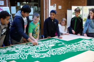
Volunteers of all ages came together to put Burnage on the map last weekend as part of our “Burnage: A Place Called Home” Heritage Lottery project charting the development of the Burnage and Kingsway Estates. Local people joined us to add their brick to the Big Burnage Lego Street Map, illustrating the crescents, circles, squares and streets designed in to the plans for the 3000 houses built by Manchester Corporation from 1923 – [1930?] in the drive for “Homes fit for Heroes” housing soldiers returning from WW1 and replacing some of the worst of Manchester’s slum areas.
The map was divided into forty six squares and Saturday saw people from the Burnage community joining us in the Library to accept the challenge of completing their square, recognising the street patterns that make up the estate. Local resident Sybil Gawkrodger declared that “Lego hadn’t been invented” when she was a girl nevertheless built the square containing the house where she was born in 1934 and has lived in ever since.
On Sunday a team of young Lego fans from our fortnightly Lego Club did their bit for their community and helped complete the map, containing around 6000 Lego pieces, in a History, Geography, construction and Maths challenge rolled into one.
The Big Burnage Lego Street Map will be displayed at an exhibition in Manchester Central Library in the Spring of 2020 alongside the people’s story of the area’s development, gathered throughout the project. A time lapse film featuring the build will launch half term Lego events in the community, engaging children and young people in designing and building houses of the future and learning more about the history of the place they call Home.


